
Before walls rise and before you begin planning your rooms and corridors, there is a quiet but crucial step that many project owners overlook—even though it determines the entire fate of their investment.
It is the moment of reading the land, understanding its fine details: where it rises, where it slopes, and what its true boundaries are on the ground.
Land surveying is not merely a routine procedure or just another document among many. It is the genetic fingerprint of the land you plan to build on.
Any error in this initial assessment can multiply thousands of times as the project progresses, turning your dream into a nightmare—whether through disputes with neighbors, drainage problems, or property boundary violations that may carry legal consequences.
In engineering and construction, accuracy starts from the foundation, and professional land surveying ensures the correct beginning.
In this article, we will explain everything you need to know about land surveying—when you need a surveyor and how to protect your property rights under modern Saudi regulations.
What Is Land Surveying?
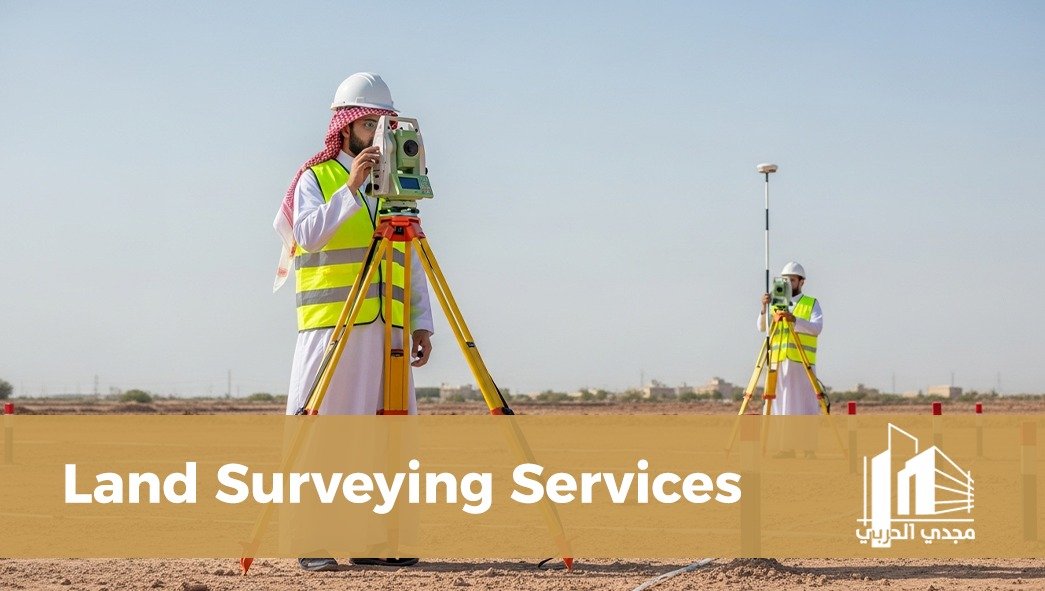
Land surveying is an engineering process aimed at measuring and determining the dimensions, area, and location of a land parcel with precision, and transferring this information from the physical site to paper or digital plans.
It involves more than measuring length and width. It also includes:
Determining geographic coordinates using GPS systems
Measuring elevations and ground levels
Identifying existing site features
In short, land surveying is the technical guarantee that prevents your land from overlapping with neighboring properties or planned road boundaries.
The Difference Between Land Surveying and Setting Out
Many property owners confuse these two terms, yet the difference between them represents the complete lifecycle of an engineering project.
Land Surveying:
This process transfers features from the site to the map. It takes place before the design stage, when the surveyor measures the land boundaries and elevations so that architects can design based on accurate real-world data.
Setting Out:
This process transfers features from the map to the site. It occurs after the design is completed, when the surveyor marks the exact positions of foundations, columns, and fences on the ground using stakes or markers to ensure that the design is implemented precisely.
Simply put:
Surveying tells you what you currently own, while setting out ensures what you designed is executed correctly.
When Do You Need a Surveyor?
Some people believe that hiring a surveyor is only necessary for large construction projects. In reality, there are several important situations where every property owner in Saudi Arabia may need a professional surveyor:
Before buying or selling land: to verify that the area stated in the title deed matches the actual land area and to avoid real estate fraud.
When applying for a building permit: municipalities require an approved survey sketch to begin permit procedures through the Balady platform.
Updating paper title deeds: converting old deeds into digital coordinate-based deeds through the Ehkam platform.
Land subdivision or consolidation: when dividing a large plot into smaller plots or merging two plots into one.
Boundary dispute cases: resolving conflicts with neighbors based on documented reference points.
Construction works: ensuring that foundations and columns are positioned exactly according to structural drawings without displacement that could affect building safety.
The Importance of Land Surveying in Saudi Arabia
Conducting a land survey is considered the foundation of any modern real estate or engineering transaction.
Its importance includes:
Compliance with the Saudi Building Code: ensuring correct building setbacks and preventing future construction violations.
Elevation determination: helping engineers design efficient sewage and rainwater drainage systems.
Accurate architectural design: architects rely on precise data; even a small measurement error can disrupt room layouts or make certain design elements impossible to implement.
Steps of Professional Land Surveying
The land surveying process involves several technical procedures to ensure maximum accuracy:
Site visit and inspection: the surveyor examines the land and identifies reference points in the surrounding area.
Establishing benchmarks: placing metal or concrete markers at land corners to serve as references throughout the construction process.
Using advanced surveying equipment: instruments such as Total Station and RTK-GPS are used to capture coordinates with centimeter-level accuracy.
Office data processing: transferring field data to engineering software such as AutoCAD to produce precise survey drawings.
Issuing the final report: delivering an approved plan that includes dimensions, total area, coordinates, and site location.
Cost of Land Surveying in Saudi Arabia
Property owners often ask about the cost of surveying. The price varies depending on several factors:
Land size: surveying a small residential plot differs from surveying large development areas.
Terrain conditions: flat land is easier to survey than mountainous or uneven terrain, which requires additional work to determine elevations.
Purpose of the survey: whether it is for subdivision, construction, or updating property deeds.
Geographical location: remote locations may increase travel and logistical costs.
Overall, surveying costs should be considered a preventive investment that protects owners from potential construction errors or long-term legal disputes.
Why Choose an Approved Engineering Office for Surveying Work?
Land surveying is not simply measuring distances—it is a critical engineering and legal document.
Choosing Majdi Al-Harbi Engineering & Safety Consultancy ensures:
Advanced equipment: using modern satellite surveying technologies and laser instruments to minimize errors.
Professional engineers and surveyors: experienced with municipal regulations and platforms such as Balady and Ehkam.
Speed and professionalism: delivering accurate survey reports quickly to facilitate your building permit procedures.
Regulatory compliance: survey drawings that are officially accepted by government authorities.
Whether you need land surveying before construction or want to verify your property boundaries, we are here to provide the precision your investment deserves.
Do not leave the boundaries of your dream to chance. Contact us today to request professional surveying services and secure your real estate future on solid engineering foundations.
(FAQ) About Land Surveying
Does an old survey sketch replace a new land survey?
In most cases, authorities require updated electronic surveying data to ensure the land coordinates match modern global coordinate systems such as WGS84, especially for new building permits.
How long does a field surveying process take?
For medium-sized residential plots, the field work typically takes one to three hours, followed by office processing that may take one to two days to produce the final survey plan.
What should I do if the survey reveals boundary overlap?
The engineering office will prepare a technical report identifying the overlap points, which can serve as strong legal evidence when resolving disputes or updating property documentation
